
Example of maritime boundary between states.
| Description | Open product specification for maritime limits and boundaries |
| Initial Document | December 2016 |
| Location | United Nations headquarters in New York |
| Document Link | IHO S-121 |
Preamble
S-121 is an open access method of providing digital representation of Maritime Limits and Boundaries (MLBs). Maritime limits and boundaries are constructs used to define maritime zones for nations around the world. With the United Nations Convention of the Law of the Sea (UNCLOS), they can form an international legal foundation of the marine domain. S-121 represents an essential extension of the International Hydrographic Organisation S-100 for the administration of the marine domain.
In December 2016, the International Hydrographic Organisation (IHO) distributed the initial document describing the standard at the United Nations headquarters in New York. This meeting began the international effort to define the core features of the S-121 standard.
There are two goals of the S-121 standard, first: to have an open, international, coordinate-based, representation of maritime boundaries and their associated rights, restrictions, and responsibilities (RRRs) that are authoritative and easy to interpret. The second goal is to facilitate the deposit of maritime boundary claims with the Division for Ocean Affairs and the Law of the Sea (DOALOS) in a spatial coordinate-based format that fulfils legal requirements under UNCLOS.
Background
Coastal States, under articles 16, 47, 75, 76 and 84 of the United Nations Convention on the Law of the Sea, are required to deposit with the Secretary-General of the United Nations charts showing: straight baselines, including closing lines of mouths of rivers and bays, and archipelagic baselines; the outer limits, as well as lines of delimitation between States with adjacent or opposite coasts, of the territorial sea (including roadsteads, article 12); the contiguous zone; the exclusive economic zone and the continental shelf. Alternatively, the lists of geographical coordinates of points, specifying the geodetic datum, may be substituted.
In its resolutions 49/28 of 6 December 1994 and 52/26 of 26 November 1997, the General Assembly requested the Secretary-General to establish appropriate facilities, as required by the Convention, for the deposit by States of maps, charts and geographic coordinates concerning national maritime zones and establish a system for their recording and publicity and to develop and maintain [such] facilities for the deposit by States of charts and geographical coordinates concerning maritime zones, including lines of delimitation, and to give due publicity thereto, as required by article 16, paragraph 2, article 47, paragraph 9, article 75, paragraph 2, article 76, paragraph 9 and article 84, paragraph 2, of the Convention. The Division for Ocean Affairs and the Law of the Sea, Office of Legal Affairs of the United Nations is the unit of the Secretariat which performs these depositary functions on behalf of the Secretary-General, as part of an integrated program on the law of the sea and ocean affairs, distinct from the usual depositary functions of the Secretary-General in respect to multilateral treaties.
Subsequently, in its resolution 59/24 of 17 November 2004, the General Assembly requested the Secretary-General to improve the existing geographic information system for the deposit by States of charts and geographical coordinates concerning maritime zones, including lines of delimitation in particular by implementing, in cooperation with relevant international organizations technical standards for the collection, storage and dissemination of the information deposited, in order to ensure compatibility among the Geographic Information System, electronic nautical charts, and other systems developed by these organizations. Recent General Assembly resolutions have noted ongoing efforts in this regard.
In 2015 the UN passed resolution A/RES/70 nominating a set of 17 Sustainable Development Goals (SDGs). Target C of SDG 14 encourages states to “Enhance the conservation and sustainable use of oceans and their resources by implementing international law as reflected in UNCLOS”. The indicator 14.C.1 is “the number of countries making progress in ratifying, accepting and implementing through legal, policy and institutional frameworks, ocean-related instruments that implement international law, as reflected in the United Nation Convention on the Law of the Sea, for the conservation and sustainable use of the oceans and their resources”. This work is required in order to assess indicator 14.2.1: “Proportion of national exclusive economic zones managed using ecosystem-based approaches”.
In addition, the General Assembly, in its annual resolutions on Oceans and the law of the sea, calls upon States Parties to the Convention to fulfill their deposit obligations. Most recently, General Assembly resolution 71/257 of 23 December 2016 calls upon States Parties to the Convention that have not yet done so to deposit with the Secretary-General charts or lists of geographical coordinates, as provided for in the Convention, preferably using the generally accepted and most recent geodetic datums (para. 6).
To facilitate the implementation of the Secretary-General’s depositary functions, coastal States are encouraged to deposit the following information, as a minimum:
- Geographic coordinates of points in decimal degrees on the straight baselines and archipelagic baselines in common global geodetic datum such as WGS 84, accompanied, as appropriate, by the relevant national legislation;
- Geographic coordinates of points in decimal degrees on the outer limits as well as lines of delimitation between States with adjacent or opposite coasts for the following maritime zones: territorial sea (including roadsteads); contiguous zone; exclusive economic zone and continental shelf, in common global geodetic datum such as WGS 84, accompanied, as appropriate, by the relevant national legislation. Ideally the points defining the outer limits should be close enough to each other to ensure that the line formed by connecting the points with geodesic lines accurately reflects the outer limit of the maritime zone(s). States Parties are also encouraged to identify in the deposit the points that are part of an international boundary. States Parties are further encouraged to accompany such deposits with the relevant national legislation and/or with references to relevant international treaties.
Accordingly, the Division for Ocean Affairs and the Law of the Sea, of the Office of Legal Affairs of the United Nations, the unit entrusted with carrying out these responsibilities on behalf of the Secretary-General, approached the International Hydrographic Organization with a request to identifying appropriate technical standards. After consultations, the S-121 project team was formed by Member States of the International Hydrographic Organization.
Description
Our planet’s oceans are subdivided by international and national laws into many areas and zones. Certainty over the locations of these zones and the rights, restrictions and responsibilities that apply to them facilitates the development of the world’s ocean resources while providing for the protection of the marine environment and safety of navigation.
At the highest level, these zones define where States exercise sovereignty and sovereign rights, and identify areas beyond national jurisdictions that fall under international jurisdiction. Together, these entities describe the common framework for the Law of the Sea.
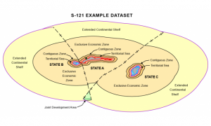
Maritime Limits and Boundaries (MLBs) are the constructs used to delineate maritime zones and forms the legal foundation of the marine domain. These maritime zones are established in law by their geographic limits and where such limit is delimiting two neighboring States, this limit is described as a maritime boundary, hence the term Maritime Limits and Boundaries (MLBs).

Example of Maritime Boundaries produced by The Pacific Community
To effectively distribute MLBs for the due publicity obligations under the Law of the Sea Convention and operational purposes, there needs to be a standard framework which ensures compatibility between users and encodes the legal character of the MLBs.
In January 2010, by adopting the S-100 Universal Hydrographic Data Model, the International Hydrographic Organisation (IHO) embarked on the development of a versatile standard framework aligned with the International Organization for Standardization (ISO) 19100 Geographic Information / Geomatics series of standards. The IHO S-100 standard aims to support a wide range of users by developing digital products and transfer standards for the marine community beyond the core hydrographic applications of the IHO. The standard opens the possibility of better marine administration by facilitating the integration of Hydrographic, Scientific and Legislative information.
The Maritime Limits and Boundaries standard – S-121 represents an essential extension of S-100for the administration of the marine domain. It enables MLBs to be described in terms of what they are, what they embody and what they are used for. S-121 establishes a framework for communicating in a digital form the geographic extents of marine areas and the associated rights and restrictions that apply to them. The framework has been developed to rigorously apply the provisions of the United Nations Convention of the Law of the Sea (UNCLOS), while allowing sufficient flexibility to accommodate the diverse implementations of the Convention by States under domestic laws.
Page Links
Links to the other areas of the website are below.
http://www.s-121.com/w/index.php/Main_Page